Great Wall of China Maps: 26 Location, Sections and History Maps
Great Wall of China Maps: 26 Location, Sections and History Maps
Our 26 Great Wall maps cover 1) the location of the Great Wall in China today, from Jiayuguan in China’s northwest to Hushan on the east coast, 2) the most popular sections being around Beijing, Gansu, and Liaoning, and 3) the historical Great Wall maps chart where the Great Wall was built in the Ming Dynasty (1368–1644) all the way back to the state walls of the Chu Kingdom (c. 650 BC).
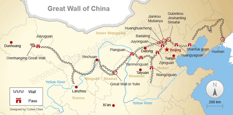
Where is the Great Wall of China Located? (Start and End)
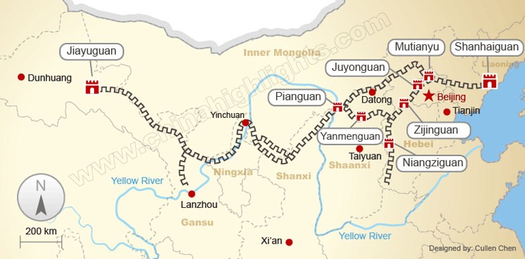
The Great Wall of China runs from west to east in northern China — from the eastern borders of Xinjiang to the Yalu River on the border of Liaoning and North Korea, with remains in 15 provinces and municipalities: Xinjiang, Inner Mongolia, Gansu, Qinghai, Ningxia, Shaanxi, Shanxi, Hebei, Beijing, Tianjin, Liaoning, Jilin, Henan, Heilongjiang, and Shandong.
You may find different answers: for example, the Great Wall starts from Jiayuguan (Gansu) in the west and ends at Shanhaiguan (Hebei) in the east. This is partially true if you are talking about the Wall as it was in the Ming Dynasty (1368–1644) when it was last constructed.
The Ming Great Wall, built over 8,500 km (5,200 mi) long, did start from Jiayuguan on Ming China’s northwest frontier but actually ended in Hushan (Liaoning) on the Manchu/Korean border, crossing 10 provincial-level areas. The Shanhaiguan arm of the Great Wall was not its longest extent in the Ming era.
Beijing Great Wall Maps (10 Sections)
The Great Wall north of Beijing is about 628 km (390 mi) and is split into many sections. The famous sections include Badaling, Mutianyu, Jiankou, Jinshanling, and Simatai. The travel time diagram below shows which Great Wall sections north of Beijing can be visited/hiked together.
- Find some ideas on our Great Wall hiking tours >>>
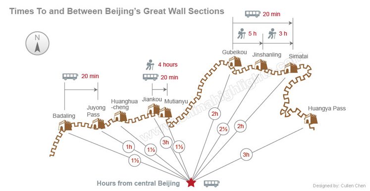
See below for more location detail on the Beijing area Great Wall sections (from west to east), then Jiayuguan and Shanhaiguan…
- Badaling
- Juyongguan
- Huanghuacheng
- Jiankou
- Mutianyu
- Baimaguan
- Gubeikou
- Jinshanling
- Simatai
- Huangyaguan
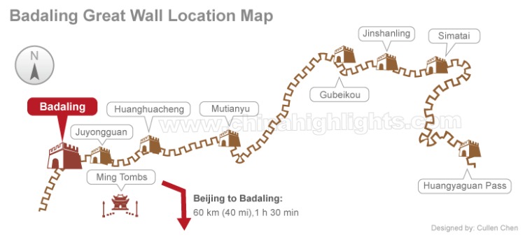
Badaling Great Wall Map
The Badaling Great Wall receives 70% of all Great Wall visitors, so it can get very crowded. However, its popularity is not without cause, as it guarded the most vulnerable route to the capital. Many Badaling tours include a visit to the Ming Tombs, to see them combine the Ming Dynasty’s great engineering feat with the tombs of the emperors who ordered it.
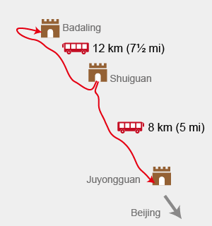
Shuiguan and Juyongguan Great Wall Map
Unless you really want to see the Shuiguan Great Wall, avoid being conned into a visit instead of nearby Badaling. Juyongguan is a Great Wall fort occupying the main valley leading to Beijing from the northwest.
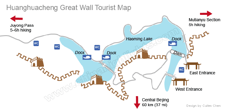
Huanghuacheng Great Wall Map
The Huanghuacheng Great Wall offers reservoir-side hiking, original Ming wall, and submerged Great Wall sections, only about 1½ hours from Beijing.
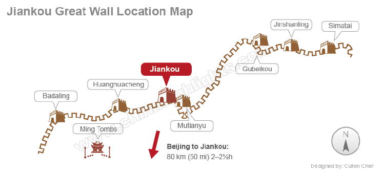
Jiankou Great Wall Map
The Jiankou Great Wall is difficult to get to, especially by local transport. It is the steepest section of the Great Wall and is recommended only for adventurous fit hikers.
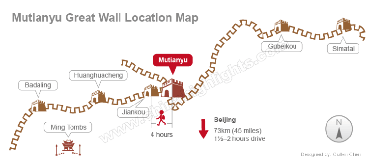
Mutianyu Great Wall Map
The Mutianyu Great Wall is the best restored Great Wall section but is less crowded than Badaling. The hike to the adjacent Jiankou section, the original unrestored Ming Dynasty wall, gets progressively steeper and more treacherous.
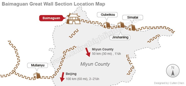
Baimaguan Great Wall Map
The Baimaguan Great Wall is mostly gone, but there are some interesting Great Wall towers and relics around the village of Baimaguan. But be prepared for some hiking. Baimaguan can be accessed via Miyun County using public transport, or more conveniently using private transport direct from Beijing.
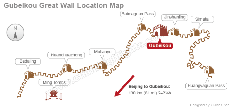
Gubeikou Great Wall Map
The Gubeikou Great Wall interestingly has original walls from the Ming Dynasty and the Northern Qi Dynasty (556 AD), though little of the latter is intact. Gubeikou is a small town in a hilly rural district, so we recommend that you arrange private transport from Beijing. It is not possible to hike to/from Jinshanling due to restricted access.
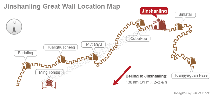
Jinshanling Great Wall Map
The Jinshanling Great Wall is highly recommended for its restored and original Great Wall architecture. The adjacent Simatai section is also very popular, though part of the classic hike between the two is currently not possible due to restricted access.
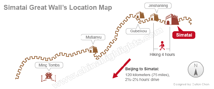
Simatai Great Wall Map
The Simatai Great Wall is well-developed for tourism, reopened recently with better facilities and access. It’s famous for its cable bridge linking to the Jinshanling section, and its steep ridge section, which is now off-limits. Not all of the Jinshanling hike is possible due to restricted access.
Huangyaguan Great Wall Map
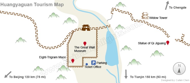
The Huangyaguan Great Wall is in Tianjin Municipality but is still closer to Beijing. It has a fully-reconstructed Great Wall and several interesting tourist features. It is the site of the official Great Wall Marathon.
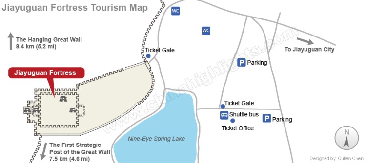
Jiayuguan Great Wall Map (2 Sections in Gansu)
The Jiayuguan Great Wall Fortress is just west of the remote city of Jiayuguan in China’s northwest. It was the western-most garrison of the Great Wall, marking the edge of China in the Ming era.
The First Abutment of the Great Wall is half an hour by bus to the south, for those who want to see where the Great Wall began.
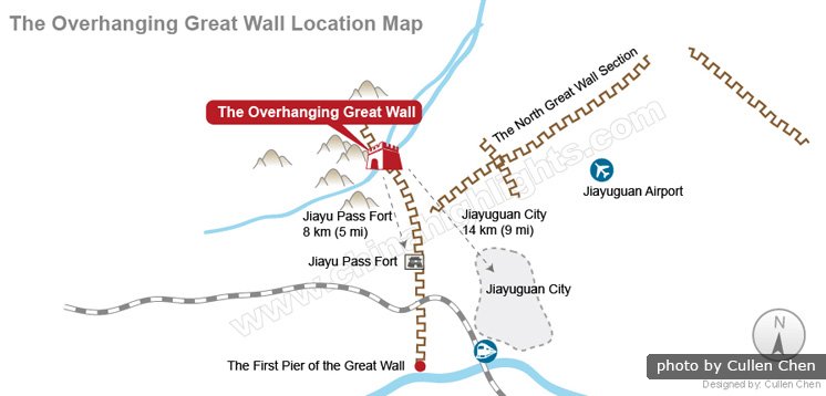
Jiayuguan’s Overhanging Great Wall Map
Jiayuguan’s Overhanging Great Wall is a reconstruction built on a perilously steep ridge with displays of Silk Road life below it.
Shanhaiguan Great Wall Map (2 Sections in Liaoning)
The main Shanhaiguan Fort is in the town of Shanhaiguan, about 300 kilometers (186 miles) east of Beijing. The Shanhaiguan Great Wall blockaded the coastal plain from Jiaoshan Mountain to the sea at Old Dragon Head.
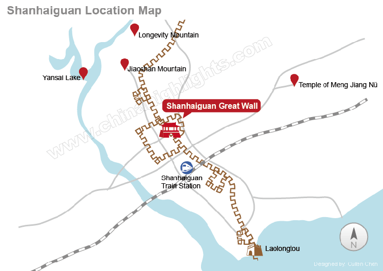
Shanhaiguan’s Old Dragon Head Great Wall Map
Shanhaiguan’s Old Dragon Head Great Wall is the striking seaward end of the Ming Great Wall, which extends out further than the low-tide mark. The smaller fort there was a crucial coastal defense in the Ming era.

Great Wall History Maps — Where and When the Great Wall Was Built
The “Great Wall” was built from the (Pre-) Warring States Period (about 656 BC) to the Ming Dynasty. During the Warring States Period (475–221 BC), seven states built their own defensive walls.
 The Warring States Period Great Wall Map
- For more on the Warring States “Great Wall” sections read Great Wall History >>>
The northern state walls were linked in the Qin Dynasty to form the first true Great Wall. China’s northern border wall changed location greatly in subsequent dynasties though some sections were reused.
Follow the path of the Great Wall in key dynasties and states back in time, from the most recent Ming Great Wall back to the first Great-Wall-like wall of the Chu Kingdom:
- Ming Dynasty (1368–1644)
- Northern Qi(550–577)
- Han Dynasty (206 BC-220 AD)
- Qin Dynasty (221–206 BC)
- State of Zhao (403–222 BC)
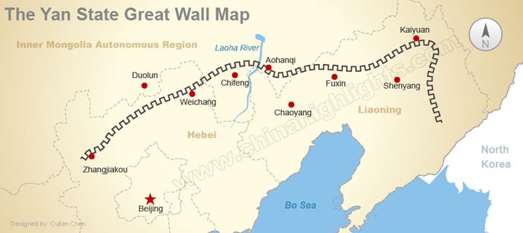
- State of Yan (312–279 BC)
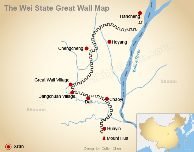
- State of Wei (358–225 BC)
- State of Qi (650–221 BC)
Where the Great Wall Was Built in the Ming Dynasty (1368–1644):
Most of the remaining Great Wall is from the Ming era. “Guan” refers to a Great Wall Fort at a crucial valley pass.
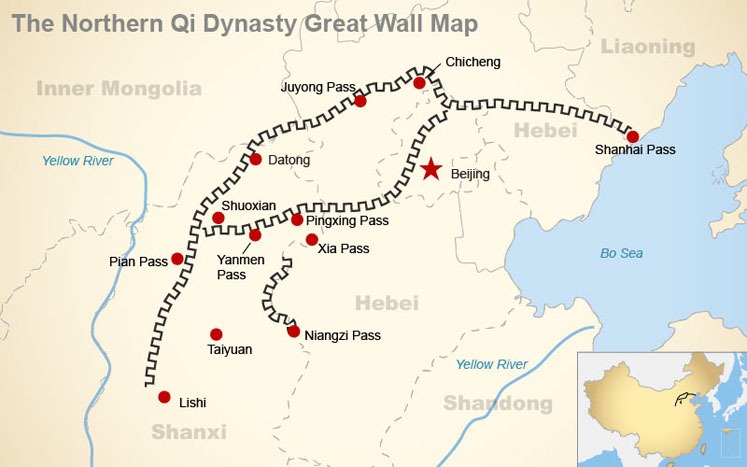
Where the Great Wall Was Built in the Northern Qi Dynasty (550–577):
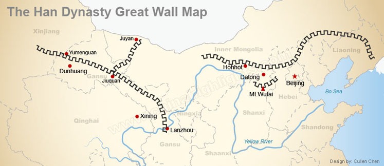
Where the Great Wall Was Built in the Han Dynasty (206 BC – 220 AD):
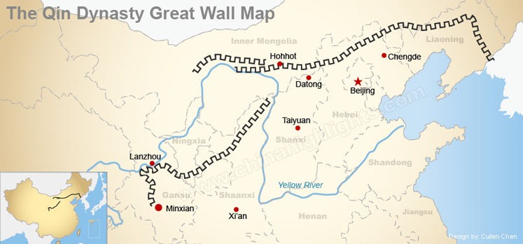
Where the Great Wall Was Built in the Qin Dynasty (221–206 BC):
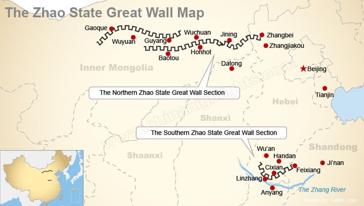
Where the Great Wall Was Built by the State of Zhao (403–222 BC):
Where the Great Wall Was Built by the State of Yan (312–279 BC):
Where the Great Wall Was Built by the State of Wei (358–225 BC):
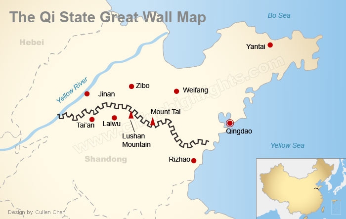
Where the Great Wall Was Built by the State of Chu (650–223 BC):


Leave a Reply
You must be logged in to post a comment.